Corston is a small village and civil parish with a population of around 500 close to the River Avon and situated on the A39 road close to Bath, North East Somerset.
Whilst Roman remains have been found between Corston & Saltford, the village itself is known to have existed since at least the Saxon period, when it was known as “Corstune”, meaning the village by the marshy stream.
In 941 King Edmund gave land at Corston to the Abbots of Bath and it is likely that they built the first church at Corston.
A Charter written around 1080 a Charter refers to Leofnoth a peasant attached to the glebe ‘aet Korstune’. The existence of glebe land suggests that there was already a priest and church serving a village.
In 1086, Corston was recorded in the Domesday book as belonging to the Abbey of Bath and having a population of 17 households. Between them they kept one cob, six pigs and sixty-two sheep, farming five acres of “lord’s land” and six acres of meadow. The location of a mill associated with the village is now lost.
By 1180 ‘Abel the Priest’ is recorded as Parson of Corston and the historic core of the village seems to have been along the current A39 where the oldest houses are now located.
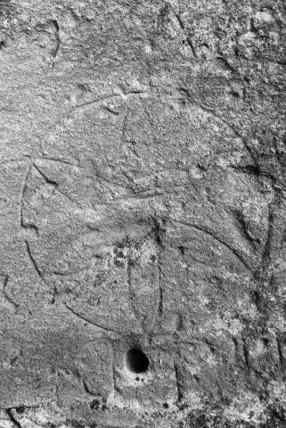
At some point during between the fifteenth and seventeenth centuries a large “daisywheel” was inscribed on the wall of 3 Wells Road, probably to bring good fortune to the householder and perhaps the village.
By the mid-eighteenth century the village was expanding up what is now Corston Lane towards the junction with the A4. By now it was associated not only with farming and market gardening but also coal mining around what is now the Globe roundabout.
To find out more visit Corston Local History Society’s website and Facebook page